|
Drill – Explosion (similar to Earthquake
drill). Example large propane tank explosion, pre-dawn, location not
known.
Net Control will state – “Drill Explosion Net Activated
use format Tango 9A or Tango 9M (include MIKE
MIKE REPORT). All stations
conduct QWA procedure.”
IN
THIS DRILL – THE VILLAGE WILL BE THE SOURCE OF THE DRILL
“EXPLOSION”
ALL OTHER AREAS ARE TO REPORT
AS FOLLOWS FOR THE DRILL:
“….QXA QWA…”
OR “ …/M1 /Y
…”
1.
FOR THIS DRILL STATIONS IN THE VILLAGE ARE TO REPORT AS FOLLOWS: (THE VILLAGE WILL REPORT TO THE VILLAGE COORDINATOR THE HIGHEST /M_
LEVEL REPORT – IN THIS CASE /M7
along with the other information. That highest /M_ LEVEL REPORT will be
recorded by the Ham Net Mapping stations.
|
Village
|
Foxtrot 1
/F
/M7 /Y
QWA end
report, out
|
|
“
”
|
Foxtrot 7
/F
/M7
/Y QWA
end report, out
|
|
|
Foxtrot 2 and 8
/F
/M7
/Y QWA end
report, out
|
|
|
|
|
|
India 1
/M6
/Y QWA
end report, out
|
|
|
India 2
/M6
/Y QWA
end report, out
|
|
|
Sierra 1 and 2
/M4
/Y QWA
end report, out
|
|
|
Sierra 6 and 7
/M4
/Y QWA end
report, out
|
|
|
Lima Stations –
all report /M4
/Y QWA
end report, out
|
|
|
Tango Stations –
all report /M2 /Y
QWA end
report, out
|
|
|
Charlie Stations - all
report /M1 /Y
QWA end
report, out
|
|
|
Bravo Stations -
all report /M1 /Y
QWA end
report, out
|
|
|
Echo Stations
- all report QXA
QWA end
report, out
|
|
|
Alfa Stations
- all report
QXA QWA
end report, out
|
At the Area Level, the detailed reports will be
posted by the Village Mapping Stations, since they will be seeking to
determine the approximate location within the Village.
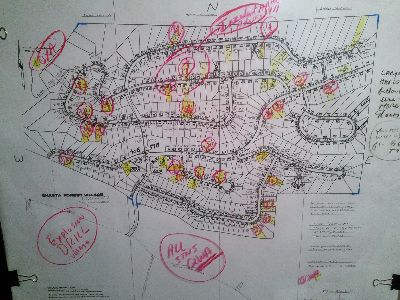
The Village Mapping Stations,
“Village Mapping 1” and “Village Mapping 2” will
post to the Village Map which should look similar to this, after posting
of the reports:
|
FROM
THIS MAP, YOU CAN SEE THE MAGNITUDES AND WHERE THE POTENTIAL
INDICATED SOURCE AREA IS LOCATION - IE., WITH THE HIGHEST MIKE
MIKE NUMBER - HERE THE NUMBER "7"
Larger Image at this link: HERE
|
At the local Neighborhood Area level, your AREA LEAD along with
your AREA MAPPING STATION(S) would use your neighborhood /M_
reports to find the most likely location of the incident in your
neighborhood. In a real
situation, such “incident location” would be relayed to 911.
2. FOR
THIS DRILL, ALL OTHER AREAS ARE TO REPORT
AS FOLLOWS FOR THE DRILL:
“….QXA QWA…”
OR “ …/M1 /Y
…”
3. In
this drill, the Village will be the “source” of the Drill Explosion
incident.
The
Village will report to the Ham Net (via Ham) the Highest /M
SCALE reported.
4. Each
Area / Neighborhood should
have stations that can do Mapping of incidents each Neighborhoods
Specific Map.
END DRAFT DRILL
|

